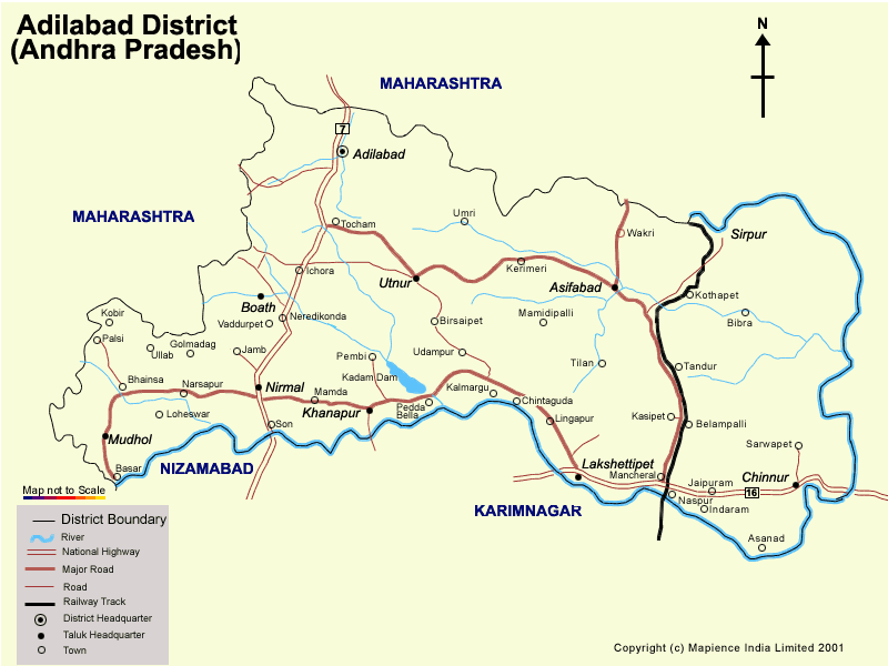
Adilabad District Map
The district of Adilabad is located between 77.46' and
80.01', of the eastern longitudes and 18.40' and 19.56', of northern
latitudes. The Satnala range crosses over the district from the north-west
to the south -east. According to the 2001 census the population of the
district is 24,79,347. The District consists of 52 Mandals and 1743 villages
and 7 Muncipalities. The District is demarcated into 5 divisions Adilabad,
Nirmal, Utnoor, Asifabad, Mancherial.
The people of Adilabad are mainly engaged in agriculture. The chief crop
grown in the district is Jowar, alongwith paddy, maize, redgram, greengram,
blackgram, soyabean, cotton, turmeric, chillies, and coriander. Fruits like
mango, banana, and papaya are also grown. Apart from this people are engaged
in the cultivation of cashew, onion, brinjal, tomato, and flowers. After
agriculture animal husbandry is the second source of income and employment
in the district. People are also engaged in sericulture after the
implementation of National Sericulture Project from 1989-90
The infrastructure of the district is developing at a rapid pace. It
provides medical facilities to its inhabitants through the following
hospitals :
· Area Hospital, at Mancherial and Bhainsa
· Community Hospitals, at Nirmal, Asifabad, Bellampall, Khanapur, Sirpur, Utnoor
Adilabad is irrigated through the major rivers like the
Godavari, the Penganga, the Pranahita and the Wardha and its tributaries
like the Kadam, Peddevagu, Sathanala etc. Power is transmitted to the
district through 28 Electrical sub-stations, of 6412 kuts. of high tensions
and 10090 kunts of low voltage lines. Nearly 99% of the district has been
electrified.
Education is one of the top priorities of Adilabad. The top Educational
Institutions in Adilabad are:
· Dr. Rajendra Prasad B.Ed College, Adilabad
· Panchsheel College of Education, Adilabad
· Sri Radhakrishna Memorial Telugu Pandit Training College, Adilabad
· Vivekananda College of Education, Adilabad
· SRKM College of Nursing, Adilabad
· Gokuldas Purushothamdas Ladda (GPL) Degree College, Adilabad
· Government Degree College, Nirmal, Adilabad, Mancherial,
· Government Degree College for Women, Adilabad
· Manjeera Degree College, Adilabad
· Nandana Degree College, Adilabad
· Vasundhara Degree College, Adilabad
A trip to Andhra Pradesh is incomplete without visiting Adilabad. The district is a favorite destination for tourists known for its lush green sceneries and amazing wild life sanctuaries.
· Kawal Wildlife Sanctuary
· Sivaram Wildlife Sanctuary
· Kadam Dam
· Pochera waterfalls
· Kuntala waterfalls
· Sri Gyana Saraswati Devasthanam in Basara
· Utnoor Temple in Utnoor
· Nagoba Temple in Kelaspur