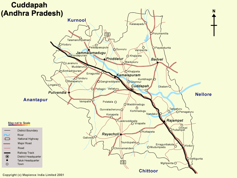
Kadapa District Map
Kadapa, is a district in the state of Andhra
Pradesh. It is located in the south-central part of the state and 8 km south
of the Penna River. The district is surrounded on three sides by the
Nallamala and Palakonda hills. It covers an area of 15,359 sq.kms. Kadapa
is surrounded in the east by Nellore, Anantapur in the west and Chittoor
district in the South, Kurnool and Prakasam districts lie in the North.
According to the 2001 census the poulation of the district is 2573.48, where
the population of males is 1303.16 and female is 1270.32.
The main rivers that flow in Kadapa district are Penna, Chitravathi,
Kunderu, Papaghni, Sagileru and Cheyeru. Agriculture is one of the main
source of occupation for the people who grow rice, jowar, cotton, turmeric,
maize, arhar, chillies, sugar cane, sesame, peanuts, and melons. The forests
of the district provide timber including the rare sandalwood, which is found
only in this region, is the chief source of revenue for the state and
nation. Another source of income for the district is handloom industry at
Madhavaram. The different places of the district is involved in the mining
of limestone and kaolin and there's an asbestos Mining processing unit at
Pulivendula.
The district of Kadapa is well connected by road and rail with the
different towns of the district and other parts of the state. There are a
number of canals, dams and reservoirlike Sunkesula Dam on Tungabadra river,
Handhri Nivas Sujala Sravanthi project and Pulivendula Canal, a Reservoir on
Buggavanka river, Galer-Nagari-Sujalasravanthi Canal that meet the water
requirement of the region.
The major tourist attractions of Kadapa are:
· Bhagavan Mahavir Government Museum, Kadapa
· Chand Phira Gumbadh, Kadapa
· Gandikota Fort, Gandikota
· Kandimallayapalli Brahmamgarimatam, Kandimallayapalli
· Masjid-e-Azam, Kadapa
· Pushpagiri Temples, Pushpagiri
· Sri Kodanda Ramaswamy Temple, Vontimitta
· Tallapaka Temples, Tallapaka
· Sri Lanka Malleswara Wild life Sanctuary, Lankamalleswaram
· Sri Venkateswara Wild Life Sanctuary, Rajampet
Different educational institutes of Kadapa offers a wide variety of subjects including arts, science, maths, nursing, law, architecture, various streams of engineering. The names of few renowned educational institutes have been included:
· Government Degree College, Lakkireddipalli, Kadapa, Rayachoty, Rajampet, Porumamilla, Jammalamadugu,
· DAW College, Kadapa
· APRM Arts & Science College, Kadapa
· Chaitanya Degree College, Kadapa
· SKR and SKR Government College for Women, Kadapa
· Sri Srinivasa Degree College, Kadapa
· Sri Venkateswara College of Arts & Computer Sciences, Kadapa
· Sweekaar Degree College of Audiology, Kadapa
· Smt Basava Rama Tarakam Memorial Law College, Chittoor
· Sri P Basi Reddy College of Law, Chittoor
· BVR College of Education, Kadapa
· Sri Malayala Swamy Telugu Pandit Trng College
· Indira Priyadarshini College of Nursing, Kadapa
· Mother Theresa School of Nursing, Kadapa